Run To Paradise
Niseko is not just a powder paradise, it's a heaven for those who find their thrills in running and hiking through the mountains.
Niseko is a wonderful place for sport – obviously, in winter most people spend their time on snow, and I do enjoy getting out on my board every now and again, but as someone who works here, winter does tend to be the busiest time of the year.
Summer or Winter? Or Both!?
Chucking on my running shoes and a bit of warm clothing only takes a few minutes. I can then roll around the snowy back roads on my own for an hour, and it really helps to clear my mind. It’s probably that same sensation as everyone is seeking on the mountain: peace, and a sense of isolation for a short time before heading back to the real world!
That said, most people don’t head out in winter, and once the snow melts is when Niseko’s running world really comes alive. There are great trails to explore, and the views are just unreal sometimes. You can see Mt Yotei from almost anywhere, and most of the time you are never far from home. There’s a great little crew of trail runners here, and they are always up for exploring although they do tend to wake up early in the morning which has never been my strength!
Enjoy the Views

The best part about running in Niseko has got to be the views. Whether you’re on the road or a trail somewhere, you are always one corner away from an incredible viewpoint. You don’t need to worry about time. Take some water and a smartphone and you’ll then be able to find your way home if you get lost as well as take some great snaps for the memories!
The Best Routes
There are so many places to run around here and to be honest; I rarely plan what I’m going to do on any given day. I tend to head out of the door and see where I end up. But these are three different routes that people might want to try.
The first is relatively short and allows a nice view of the river between Hirafu and Kutchan as well as some stunning views of Mt Yotei.
The second one is the full-monty of a loop around Mt Yotei, definitely something where you need to be prepared for a day out on the roads. It is one of my dreams to start a marathon event which is a circle of Mt Yotei.
The last one is a creation of Yoshitaka Toge, a great friend of mine and the owner-operator of Sprout Coffee down in Kutchan. It’s hitting the trails and climbing a couple of peaks and a really incredible day out with friends. So, three very different challenges on three different routes.
Route 1: Riverside Loop

Length: 12km
Vertical: Approx. 200m
Start & Finish: Hirafu Intersection
Type: Trail and road mix
Required: Decent off-road running shoes
This route is perfect for anyone who is regularly running around 10km or perhaps wanting to spend 45-90 minutes out exercising in summer. A nice easy warm-up jogging down from Hirafu along the pavement passed Izumikyo. The first photo spot would be on the St Moritz bridge where the view of Mt Yotei over the river is spectacular in the right light.
After the bridge, you hook a left and drop down to the river. The path along here can be pretty muddy at times, and after heavy winds, there may be a few branches down, but it’s peaceful and quiet for about 3-4 km down into Kutchan. You’ll get another great view of Mt Yotei across the farm fields. As you run the final stretch into Kutchan, you can see the Shinkansen work being done as tunnels start to be dug.

Once you reach the bridge in Kutchan, you can turn around and come back the same way or turn right and run back up the road. This is a pleasant long hill to stretch the legs out, but before you start be sure to grab another photo from the bridge this time looking back up at Hirafu and Mt Annupuri.
If I feel like I have a few extra kilometres in me on this run, I might carry on up Route 5 and turn left to Lake Hangetsu and do a loop around there. This probably adds about a total of 6-7 km to the length but is a beautiful addition to the run. The loop around the lake is about 2km and all single-track trail through the woods with some amazing views down into the volcanic lake.
Route 2: Mt Yotei Loop
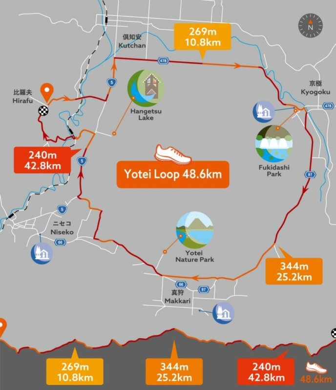
Length: 48km
Vertical: Approx. 700m
Start & Finish: Hirafu Intersection
Type: All road or pavement
Required: Definitely water bottles and some fuel. You’ll be out for at least four hours, so I’d recommend sunblock and a cap as well in summer. Shoes that work for a marathon are fine.
Before you consider setting out on this one, be sure to pack appropriately. There are a couple of places along the way you can fill up from natural springs as well as a convenience store about halfway. It sounds daunting to consider this loop, but apart from a couple of stretches, it’s almost all on pavement and will afford you amazing views of each side of Mt Yotei. Car traffic in the area is minimal, especially in summer.
Until I ran this, I never really realised how different the mountain looks from each side. The view from Hirafu really does remind us of Mt Fuji with the iconic volcano shape, but out around Makkari, the mountain takes on a different shape.
Also, the gently rolling hills around the foot of the mountain are really pleasant to run along. If you’re doing this in August, it might be best to start early, that way you get the morning sunlight and should avoid the hottest time in the afternoon. If you are running in June or September, it will be temperate most of the day.

After running down to Route 5, I would turn left and head down towards Kutchan. Turn right just after Homac, and now you have a long straight stretch most of the way to Kyogoku. This has a couple of relatively short but steep hills as well as a couple of stretches without pavement. Run on the right-hand side of the road facing the traffic so you can see what’s coming, although cars are pretty few and far between and they are very friendly to runners, hikers or cyclists.
The road then winds up into Kyogoku, and your first pit stop at Fukidashi Park after about 17 km. Here you can drink fresh mineral water that has run down from Mt Yotei as well as refill your water bottles, and Lawson convenience store is just past the park if you need a snack. Turning right after Lawson you will now head round towards Makkari. There is hardly any traffic along this stretch, and if music is your thing this is the time to plug in the headphones, but don’t forget to keep looking to your right where Mt Yotei’s face will be changing every step of the way. You’ll get some incredible vistas across farm fields and through tree clearings.
After passing alongside Makkari Town through the farming roads, you have another chance to refuel at about 33 km from another natural Mt Yotei spring. This is your final fuel stop so worth making sure you take enough water with you as there is still another 15 km to go! About 3 km after the spring you can take a short cut through to Route 5 again. You’ll have to run about 4 km along the road, but there is plenty of space at the side, so it’s not dangerous at all.
Just before you get to the turnoff for Lake Hangetsu, take a left and run down passed Hirafu Station and Country Resort. This leaves you with a nice little climb up to Kabayama, and then you are home and dry. It’s an epic run and something that will stick in the memory for a long time.
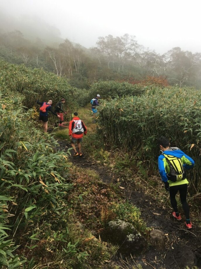
Route 3: Niseko Trail Loop
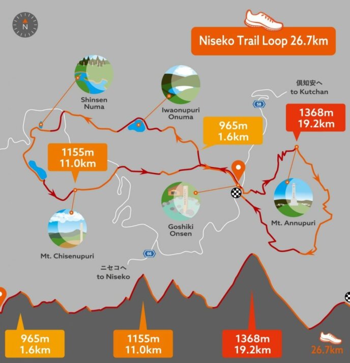
Length: 27km
Vertical: Approx. 2,100m
Start & Finish: Goshiki Onsen
Type: 95% trails
Required: Good trail running shoes, waterproof jacket, water bottles and fuel. You’ll have the chance to refuel about two-thirds of the way around, but apart from that, you need to carry everything.
This is the big one! You will be out for around 5-6 hours minimum, and you are heading up into the mountains. You’ll be hitting the peaks, so it is essential to carry gear that is appropriate for the changeable weather and temperature difference between the valleys and the summits.
But the views on a clear day will blow your mind. Do not forget your phone or camera for this one! You’ll take in the marshlands of Shinsennuma, the lake at Naganuma and the peaks of Chisenupuri, Nitonupuri and finally Niseko-Annupuri.
This is the route with Yoshitaka Toge of Sprout Coffee as its brainchild. A local trail running inspiration as well as a legend for delicious coffee, hitting the trails with him is always a treat. It’s worth doing this route with a few people and running together. There are some tough climbs and descents, and as it is all off-road, it’s good to keep people nearby in case of injury as well as to share memories with.
The car park just passed Goshiki Onsen is where you want to start, and this will be a spot you come back through after about 15 km, so leave some drinks and fuel in the car. This also allows you to call it a day if the weather turns or if someone gets injured. Head up the steps past the onsen and follow the route which takes you passed the lake at Iwaonupuri and up into Shinsennuma where the views across the marshes of Mt Yotei are amazing.
The route then winds around passed another lake called Naganuma, literally “long lake”, before your first big climb up Mt Chisenupuri. On a clear day you can enjoy views down to the sea and of the whole Niseko-Annupuri range, and it’s a good place to stop for a snack. The route then takes you down Chisenupuri and up along Iwaonupuri before the descent down to the car park. Take your time to refuel here because next up is Mt Annupuri.
There is a climbers’ log book at the entrance to the climb, and it’s always worth jotting your name down in case something goes wrong – the climb up to the summit is about 2 km, and it is runnable though a tough section!
Again, you will be afforded magnificent views from the ridgelines, and once you get to the summit, you’ll see the iconic hut at the top of the mountain which features in lots of winter photos as the start point for people’s powder adventures. In summer, your view will be dominated by the imposing and perfectly shaped Ezo-Fuji – our own Mt Yotei.
From the peak, you descend rapidly down towards Annupuri ski resort, a fun and fast descent if you still have something in the legs! Before you reach the bottom lifts, you take a right and find yourself faced with one final cheeky ascent back up towards Goshiki.
The feeling of completing this run with a group of friends is right up there with taking on a race or tearing around the mountain on skis or a snowboard in winter. If running is your thing, this is the one I would recommend whole-heartedly as a day you will never forget!
--
For more extreme summer time fun, check out our video about Flow Trail Mountain Biking in Niseko.